![]()
Entry Date: 22.05.2021, at 15:50:00 hrs (local)
Whangarei - Whangarei
Gale warning
| PRID: | 12216 |
|---|---|
| LegID: | 331 |
| LegNo: | 79 |
| Latitude: | S035°43.40' |
| Longitude: | E174°19.60' |
| Day#: | 1076 |
| Log (Day): | 12 nm |
| Log (Leg): | 21 nm |
| Log (Total): | 55131 nm |
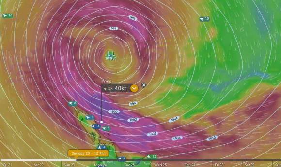
New Zealand Coastal Situation
A ridge of high pressure covers southern and central New Zealand through to Wednesday, although a front moves north over the South Island late Sunday and Monday. A deep subtropical low lies slow moving northeast of New Zealand through to Wednesday, directing strong southeasterlies over the North Island.
Brett Coastal Forecast
Gale warning
Today: Southeast 30 knots, rising to 45 knots this evening. Sea becoming high. Easterly swell rising to 4 metres offshore. Poor visibility in rain.
Sunday: Southeast 45 knots. Sea high. Easterly swell 8 metres for a time offshore, easing. Poor visibility in rain, easing in the evening.
Monday: Southeast easing to 35 knots early. High sea easing. Heavy easterly swell.
Tuesday: Southeast 35 knots. Sea very rough. Heavy easterly swell.
Wednesday: Southeast easing to 30 knots. Very rough sea easing. Heavy easterly swell.
Issued: 12:15pm Saturday 22 May 2021